.png)
 German (DE)
  English (US)
  Spanish (ES)
  French (FR)
  Hindi (IN)
  Italian (IT)
  Russian (RU)
  1 day ago
3
1 day ago
3
; damage after quake (right)")
Before earthquake (left); damage after quake (right)
NEW DELHI: Isro has released pictures of the damages caused by the deadly earthquake in Myanmar that killed more than 1,700 people. The images were taken by the earth imaging and mapping satellite, Cartosat-3.
The earthquake's epicenter was near Mandalay, Myanmar’s second-largest city, which suffered extensive damage. The tremors also shook the capital, Naypyidaw, and other regions, leading to the collapse of roads, infrastructure, and residential buildings, the space agency noted.
The impact was not limited to Myanmar, as neighboring countries also felt the shockwaves. In Thailand, residents in Chiang Mai and northern areas reported experiencing tremors strong enough to cause damage.
Explaining the likely cause of the quake, Isro said, "Myanmar is located near the convergent boundary of the Indian and Eurasian plates, where the Indian Plate is moving northward toward the Eurasian Plate at a rate of about 5 cm per year. In addition to that Myanmar also sits near several smaller fault zones, such as the Sagaing Fault, which runs through central Myanmar."
"The Sagaing fault is a significant active strike-slip fault that accommodates lateral motion between the blocks of the Indian and Eurasian plates. The present earthquake was likely associated with the release of accumulated stress along the Sagaing fault or its accessory faults in the region," it added.
Before (left); after (right)
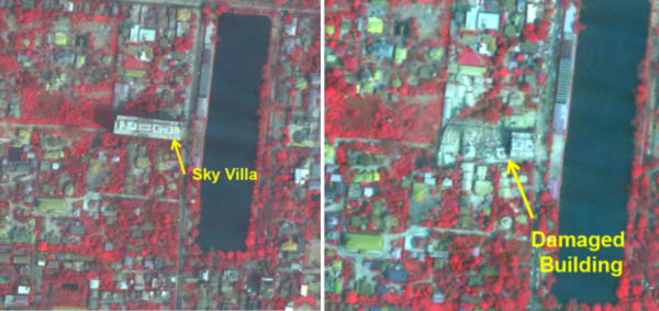
The satellites captured the destruction casued to the infrastructure including collapse of buindings.
"Significant damage to infrastructure in Mandalay city was observed, with major landmarks such as Sky Villa, Phayani Pagoda, Mahamuni Pagoda and Ananda Pagoda, University of Mandalay and several others suffering either complete or partial damage. In Sagaing city, damage was observed in the Ma Shi Khana Pagoda, along with several monasteries and other buildings," the space agency said in a statement.
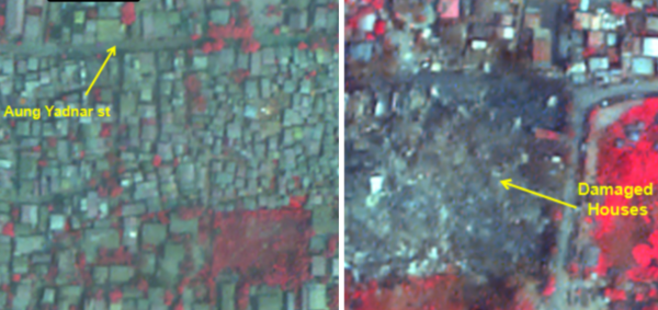
Aung Yadnar st: Condition before the earthquake (left); destruction due to the earthquake (right)
The space agency reported that a powerful 7.7-magnitude earthquake struck Myanmar on March 28, followed by a strong 6.4-magnitude aftershock. The epicenter was located at 22.013°N, 95.922°E, at a depth of 10 km near the Sagaing-Mandalay border.
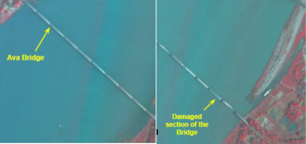
Ava bridge: Before (left); after (right)
The images also captured the collapse of the Ava bridge near the Inn Wa city.
"As seen from the imagery, the earthquake caused the complete collapse of the historic Ava (InnWa) Bridge on the Irrawaddy River, near Inn Wa City," Isro's statement said.
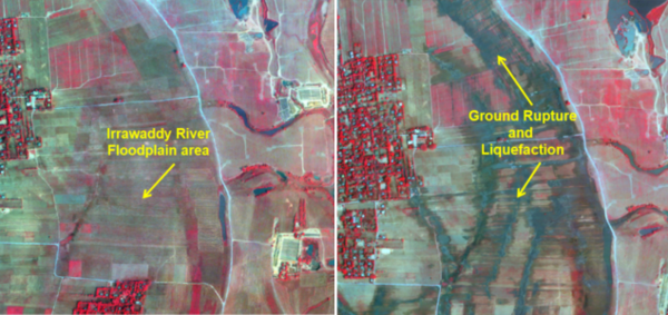
Irrawaddy river floodplain: Before (left); after (right)
The cracks and ground ruptures caused due to the quake in the floodplains of the Irrawaddy River were also captured by the satellite.
"Cracks/ground ruptures in flood plains of Irrawaddy river with associated liquefaction was also observed," the statement said.


Comments